The Great Earthquake of 26 December 2004 in Southeast Asia
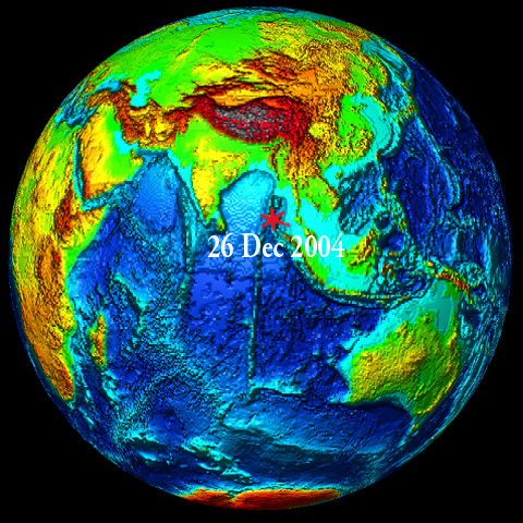

On Sunday, 26 December 2004, the greatest earthquake in 40 years occurred about 150 kilometers off the west coast of northern Sumatra Island in Indonesia. The earthquake generated a disastrous tsunami that caused destruction in 11 countries bordering the Indian Ocean.
Origin Time and Epicenter
The great tsunamigenic earthquake occurred on Sunday, 26 December 2004, at 00:58:50 UTC (6:58:50 a.m. local time). The epicenter was at 3.298 N, 95.779 E and its focal depth was very shallow (much less than 33 km - possibly about 10km)
Magnitude and Energy Release
The quake was widely felt in Sumatra, the Nicobar and Andaman Islands, Malaysia, Myanmar, Singapore, Thailand, Bangladesh and India.
According to the U.S. Geological Survey (USGS NEIC (WDCS-D)), the moment magnitude of the earthquake - which is larger than the Richter magnitude - was 9. Such magnitude would make this earthquake to be the fourth largest in the world since 1900 - and the largest since the 1964 Alaska earthquake.
However, on the basis of subsequent analysis of additional seismograms from around the world, scientists at Northwestern University determined the earthquake's magnitude to be 9.3 and not 9.0, as originally estimated. Therefore, the calculated energy release was 1.13 X 10 (raised to the 30 power) dynes-cm , or three times larger than originally thought. The revised estimate makes this earthquake to be the second largest ever instrumentally recorded. The largest earthquake ever recorded, which measured 9.5, was in Chile on May 22, 1960.
 Tectonic Setting
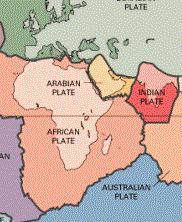
The region where the great earthquake occurred on 26 December 2004, marks the seismic boundary formed by the movement of the Indo-Australian plate as it collides with the Burma subplate, which is part of the Eurasian plate. However, the Indo-Australian tectonic plate may not be as coherent as previously believed. According to recent studies reported in the Earth and Planetary Science Letters (vol 133), it apears that the two plates have separated many million years ago and that the Australian plate is rotating in a counterclockwise direction, putting stress in the southern segment of the India plate.
For millions of years the India tectonic plate has drifted and moved in a north/northeast direction, colliding with the Eurasian tectonic plate and forming the Himalayan mountains. As a result of such migration and collision with both the Eurasian and the Australian tectonic plates, the Indian plate's eastern boundary is a diffuse zone of seismicity and deformation, characterized by extensive faulting and numerous large earthquakes.
USGS graphic showing the migration of the Indian tectonic plate
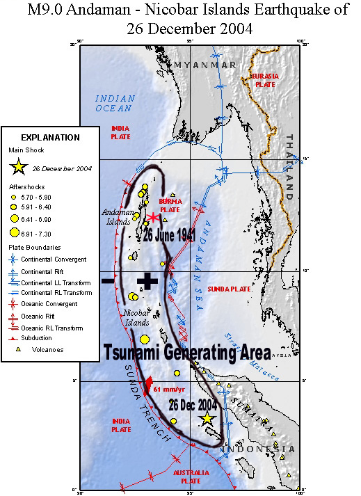
The epicenter of the 26 December 2004 earthquake was near the triple point junction of three tectonic plates where major earthquakes and tsunamis have occurred in the past.
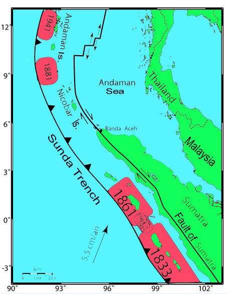
Previous major earthquakes have occurred further north, in the Andaman Sea and further South along the Sumatra, Java and Sunda sections of one of the earth's greatest fault zones, a subduction zone known as the Sunda Trench. This great trench extends for about 3,400 miles (5,500 kms) from Myanmar (Burma) south past Sumatra and Java and east toward Australia and the Lesser Sunda Islands, ending up near Timor. Slippage and plate subduction make this region highly seismic. The volcanoes of Krakatau, Tambora and Toba, well known for their violent eruptions, are byproducts of such tectonic interactions.
In addition to the Sunda Trench, the Sumatra fault is responsible for seismic activity on the Island of Sumatra. This is a strike-slip type of fault which extends along the entire length of the island.
The Burma plate encompasses the northwest portion of the island of Sumatra as well as the Andaman and the Nicobar Islands, which separate the Andaman Sea from the Indian Ocean. Further to the east, a divergent boundary separates the Burma plate from the Sunda plate.
More specifically, in the region off the west coast of northern Sumatra, the India plate is moving in a northeastward direction at about 5 to 5.5 cm per year relative to the Burma plate.

Earthquakes originate at two principal tectonic sources in Indonesia. The major tectonic feature in the region is the Sunda Arc that extends approximately 5,600 km between the Andaman Islands in the northwest and the Banda Arc in the east. The Sunda Arc consists of three primary segments; the Sumatra segment, the Sunda Strait Segment and the Java Segment. These locations represent the area of greatest seismic exposure, with maximum earthquake magnitudes of up to 7.75 or even more on the Richter scale (as this latest earthquake with Moment Magnitude 9 indicates - and which occcurred on the Sumatra segment).
The region where the earthquake occurred - and particularly the Andaman Sea - is a very active seismic area. According to the literature (Bapat 1982) from 1900 to 1980, a total of 348 earthquakes were recorded in the area bounded by 7.0 N to 22.0 N and 88.0 E to 100 E. However, only five of these earthquakes in the Bay of Bengal had magnitudes equal to or greater than 7.1 ( ranging from 7.1 to 8.5). Also Sumatra is in the center of one of the world's most seismically active regions. Earthquakes with magnitude greater than 8 struck Sumatra in 1797, 1833, and 1861. Earthquakes with magnitude greater than 7 struck offshore islands in 1881, 1935, 2000, and 2002.

As of 1 January, 2005, there were about 84 aftershocks with magnitudes ranging from 5.0 to 7.0 in the region of Northern Sumatra and the Nicobar and Andaman Islands. Twenty six (26) of these - including the largest- occurred on 26 December 2004, the same day as the main earthquake. Since 1 January 2005, many more aftershocks have occurred. The aftershocks are expected to continue for several weeks and months. Some of the major aftershocks have occurred in the vicinity of the epicenter of a past earthquake which had occurred on 26 June 1941 and some in the area near the Nicobar Islands where the 1881 earthquake had occurred.
The distribution of afteshocls suggests that the earthquake resulted by the sudden slip of these two plates and that there was a slip as well as an upward thrust of the Burma plate along this boundary.
| MAGNITUDE | DATE | UTC-TIME | LATITUDE | LONGITUDE | DEPTH | REGION |
| 8.9 | 2004/12/26 | 00:58:51 | 3.298 | 95.779 | 10.0 | West Coast of Northern Sumatra |
| 5.9 | 2004/12/26 | 01:48:47 | 5.393 | 94.423 | 10.0 | West Coast of Northern Sumatra |
| 5.8 | 2004/12/26 | 02:15:58 | 12.375 | 92.509 | 10.0 | Andaman Islands |
| 6.0 | 2004/12/26 | 02:22:02 | 8.83 | 92.532 | 10.0 | Nicobar Islands |
| 5.8 | 2004/12/26 | 02:34:50 | 4.104 | 94.184 | 10.0 | West Coast of Northern Sumatra |
| 5.8 | 2004/12/26 | 02:36:06 | 12.139 | 93.011 | 10.0 | Andaman Islands |
| 6.0 | 2004/12/26 | 02:51:59 | 12.511 | 92.592 | 10.0 | Andaman Islands |
| 5.9 | 2004/12/26 | 02:59:12 | 3.177 | 94.259 | 10.0 | West Coast of Northern Sumatra |
| 6.1 | 2004/12/26 | 03:08:42 | 13.808 | 92.974 | 10.0 | Andaman Islands |
| 7.3 | 2004/12/26 | 04:21:26 | 6.901 | 92.952 | 10.0 | Nicobar Islands |
| 5.7 | 2004/12/26 | 06:21:58 | 10.623 | 92.323 | 10.0 | Andaman Islands |
| 5.7 | 2004/12/26 | 07:07:10 | 10.336 | 93.756 | 10.0 | Andaman Islands |
| 5.8 | 2004/12/26 | 07:38:25 | 13.119 | 93.051 | 10.0 | Andaman Islands |
| 6.5 | 2004/12/26 | 09:20:01 | 8.867 | 92.382 | 10.0 | Nicobar Islands |
| 6.2 | 2004/12/26 | 10:19:30 | 13.455 | 92.791 | 10.0 | Andaman Islands |
| 6.3 | 2004/12/26 | 11:05:01 | 13.542 | 92.877 | 10.0 | Andaman Islands |
The distribution of the larger aftershocks indicates that the two tectonic plates (the India plate and the Burma subplate) slipped for about 1,200 km along their boundary. The aftershocks extend from northern Sumatra (approximately 3 degrees North Latitude) to the Andaman Islands (approximately 14 degrees north). Therefore, the length of the overall rupture is estimated to be about 1,200 km.
However, the slippage does not appear to be continuous. It appears that it occurred in two phases along two sections of the great fault that parallels the Sunda Trench. The rupture started near the epicenter off the western coast of North Sumatra and progressed - at a fast rate - northward to the Andaman islands along a preexisting major fault. For the first 500-600 km the orientation of the rupture (the quake's strike) was appoximately 320- 330 degrees. Subsequently the rupture continued - at a much slower rate in an approximate North-South direction - for another 500 -600 km along another segment of the northern Sunda fault system. This is probably the same segment that ruptured during the 1941 Andaman Islands earthquake - which also generated a destructive tsunami.
It has been estimated that this megathrust faulting along the India and Burma boundary has resulted in a shift that averaged about 15 meters with maximum slip being 20 meters. The vertical upward movement of the sea floor may have been several meters - possibly as much as 5 meters or more in some places. At some of the islands there may be subsidence while at others there was upthrusting. Field surveys of the islands off Summatra and of the Nicobar and Andaman islands - when completed - will provide better estimates of net crustal movements.
The Great Tsunami of 26 December 2004 in the Indian Ocean
 The great earthquake of December 26, 2004 was extremely damaging and resulted in many deaths. However, most of the destruction and deaths were caused by the catastrophic tsunami waves it generated. Massive tsunami waves wiped out entire coastal areas across southeastern Asia, Sri Lanka, India, Thailand, Myanmar and islands in the Andaman Sea and the Maldives in the Indian Ocean.
DEATH TOLL
The tsunami waves caused considerable destruction and killed people more than 2,000 kilometers away, in the Seychelles and in Somalia . As of February 10, 2005, the global death toll has been raised to 226,566 and continues to rise. The demographics in this part of the world are not very good. There are many remote islands in the Nicobar, Andaman, Maldives and off the African coasts, so there are many unreported deaths.No Tsunami Warning Issued
The large tsunami which struck 11 of the nations that border the Indian Ocean was a complete surprise for the people living there, but not for the scientists who are aware of the tectonic interactions in the region. Many seismic networks recorded the massive earthquake, but there was no tide gauges or other wave sensors to provide confirmation as to whether a tsunami had been generated. There was no established communications network or organizational infastructure to pass a warning of any kind to the people coastlines.No Tsunami Warning System exists for the Indian Ocean as there is for the Pacific. The Pacific Tsunami Warning Center in Honolulu had no way of providing warning information to the region. Part of the problem is that most of the countries in the region have underestimated their potential tsunami threat from the Northern end of the Sunda Trench. Review of historical records would have revealed that a very destructive tsunami occurred in 1941, in the same general area. This particular tsunami killed more than 5,000 people on the eastern coast of India, but it was mistaken for a "storm surge". Thousands more must have gotten killed elsewhere in the islands of the Bay of Bengal in 1941, but there has been no sufficient documentation. Unfortunately, no Regional Tsunami Warning System, Preparedness Program, or effective Communications Plan exist for this part of the world.
 Tsunami Generating Area
Based on the plate tectonics of the convergence zone that has formed the SundaTrench and on aftershock distribution, the tsunami generating area is believed to be a somewhat irregular, broken up ellipsoid which changes from a Northwest Southeast orientation of about 330 degrees in the lower section to an almost North - South 360 degrees orientation in the upper section.The major axis of the ellipsoid is estimated to be approximately 1,200 km and its minor axis to be about 180 km. It is believed that this ellipsoid type of block movement occurred along an oblique but very shallow subduction angle and that the Burma subplate was thrusted upward by several meters (as much as 5m in some places) with an oblique lateral movement of as much as 15 meters and possibly as much as 20 meters along the southern tsunami generating region. These are rough estimates which may have to be revised when more data becomes available. Also, the earthquake's relatively slow slippage along the 1,200 kms long rupture added additional energy to tsunami generation.
A preliminary estimate of the Tsunami Generating Area ( Modified USGS map showing the earthquake epicenter, the distribution of initial major afteshocks ,and the interaction of major tectonic plates along the Sunda Trench )
A personal communication was received from Indonesia that at Simeulue, an island close to the epicenter off the coast of Northern Sumatra, there was only vertical displacement but no tsunami. Surprisingly, residents of beach communities claimed that no tsunami waves were observed, no deaths from the tsunami were reported, but that the island rose and is now several kilometers longer. No information has been provided on how much the island rose, but preliminary data indicates that it may have been as much as 5 meters.
The reason that the tsunami did not cause deaths and destruction on Simeulu Island is because the amount of crustal uplift was greater than the height of the waves. Additional eyewitness accounts or observations will help clarify whether this was the case.
A preliminary estimate is that the tsunami generating area involved about 280-300,000 square kilometers of the ocean floor. This estimate will probably be revised and corrected as well, as more data on aftershock distribution becomes available and when tsunami travel times to operating tide gauge stations in the Bay of Bengal are obtained - if any exist or survived the tsunami impact.
Also, field surveys and data collection will help determine the net crustal displacements on the islands off Sumatra and in the Nicobar and Andaman Islands. This will permit more accurate determination of the volume of undersea crustal displacements that contributed to such catastrophic tsunami generation.
These results have implications for why Sri Lanka suffered such a great impact and also indicate that the chances of similar large tsumanis occurring in the same area are reduced.
 Evaluation of tsunami reccurrence in the region
Indonesia is surrounded by four major tectonic plates, the Pacific, the Eurasian, the Australian and the Philippine plates. All these major tectonic plates and their subplates are presently active. Major earthquakes and tsunamis can be expected in the semi-enclosed seas and along the Indian Ocean side of Indonesia. Major earthquakes in the semi-enclosed seas can generate destructive local tsunamis in the Sulu, Banda and Java Seas. Major earthquakes along the Sunda Trench can generate tsunamis that can be destructive not only in Indonesia but to other countries bordering the Indian Ocean.In the immediate vicinity off Northern Sumatra, most of the stress and energy that had accumulated were released by the crustal movement that caused the 26 December 2004 earthquake. The subduction of the India tectonic plate underneath the Burma plate caused upward thrusting of an extensive block and generated the destructive tsunami. There was significant slip and rupture for about 600 km and possibly a less significant slip for another 400 km along the Nicobar and Andaman Islands. Thus, it is unlikely that another major earthquake will occur in the immediate region off Northern Sumatra in the near future, but stress will start building up again. Also, it is quite possible that not all of the energy was released in the Nicobar and Andaman section of the Sunda Trench by the 26 December 2004 earthquake - in which case the next major earthquake could occur there sooner than one off Northern Sumatra.
Although the danger of another major tsunami has passed, strong aftershocks in the region could possibly generate small local tsunamis. Aftershocks can be expected to last for many weeks and months in the region, but they should diminish in strength with the passage of time. Most of the aftershocks will result from gravitational adjustments of the crustal material that was moved during the major earthquake. The aftershocks represent nature's way of restoring stability and temporary equlibrium. It is unlikely that a destructive tsunami will occur again soon in the same region, however caution is advised for the coastal residents in Northern Sumatra and in the Nicobar and Andaman islands. If an afteshcok is stong enough and it is strongly felt, evacuation to higher elevation is advised. In fact, strong shaking of the ground is nature's warning that a tsunami may be imminent.
Furthermore - and though the stress in the region off Northern Sumatra has been released by the 26 December 2004 earthquake - this does not necessarily mean that another earthquake further north or further south cannot occur. In the North, a repeat of the 1881 Nicobar Islands or of the 1941 Andaman Islands earthquakes and tsunamis can be expected in the future - although it is difficult to say how soon. Such events seem to occur on the average of every 50 years.
To the South, the movement of the tectonic plates may have added stress along other tectonic boundaries. A repeat of earthquakes and tsunamis along the Sunda Trench off the central region of Western Sumatra, as in 1833 (magnitude 8.7) and 1861, is very possible. Such earthquakes and tsunamis can be expected every hundred years or so. In fact, the 26 December 2004 earthquake occurred along the section that did not rupture during the 1861 earthquake. It took approximately 144 years to occur. However, this does not mean that it will take that long for the next destructive tsunami to occur again off central or northern Sumatra. Destructive tsunamis are possible in the next 20 years or less. A repeart of the 1833 earthquake could generate a devastating tsunami. This section of the Sunda megathrust is one of the more likely sources of a destructive tsunamis in the region.
Other seismic regions further south have the potential of generating destructive tsunamis even sooner. As in 1977, a major tsunami could be generated in the eastern section of the Sunda Trench that would affect not only Indonesia, but the northern and northwestern coasts of Australia.
Effects of the 26 December 2004 Tsunami in the Bay of Bengal and in the Indian Ocean
 Waves of up to 10.5 meters in height struck Northern Sumatra, the Nicobar and Andaman Islands, Thailand, Sri Lanka, India. Destructive waves also struck the Maldives, Somalia, Kenya and the islands off the African coast. The tsunami was recorded by tide gauge stations not only in the Indian Ocean, but in the Pacific as well. In Manzanillo, Mexico, the tide gauge recorded a wave of 2.6 meters.
Eighteen (18) countries bordering the Indian Ocean were affected by the tsunami. These were: Indonesia, Thailand, India, Sri-Lanka, Malaysia, Myanmar, Bangladesh, Maldives, Reunion Island (French), Seychelles, Madagascar, Mauritius, Somalia, Tanzania, Kenya, Oman, South Africa and Australia.
DEATH TOLL -The tsunami had its greatest impact and casualties in Indonesia, Thailand, India, Shri-Lanka, Malaysia, Myanmar, Maldives and Somalia. Eleven (11) countries reported deaths, some in tens of thousands.The death toll thus ar has been reported as 226,566. However, this is an underestimate as thousands are still missing and many more may have been killed in remote islands. More than 1.5 million people were left homeless around the region.
The following is a brief summary compiled from numerous government, U.N., and media sources.
Efforts are being made to obtain tsunami wave heights. This section of the report will be changed and updated as more information becomes available.
INDONESIA
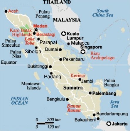
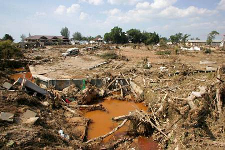
Tsunami waves of up to ten meters swamped the smaller outlying islands of Sumatra as well as its northern and western coastal areas - about 100 km (60 mi) from the earthquake epicenter . Hardesh hit was the northern Aceh province. Nearly all the casualties and damage took place within this province. Very heavy damage occurred as far South as Tapatkuan. The waves also propagated around the northern tip of Sumatra into the Straits of Malacca and struck coastal settlements along the northeast coast as far east as Lhokseumawe.
According to the latest official reports (Ministry of Health) 166,320 people were killed, 127,774 are still missing and 655,000 people were displaced in Northern Sumatra. A total of 110 bridges were destroyed, 5 seaports and 2 airports sustained considerable damage, and 82% of all roads were severy damaged. The death toll is expected to rise. The following is a summary of the tsunami impact in Northern Sumatra.
 Banda Aceh - The tsunami waves completely destroyed the city of Banda Aceh's infrastructure and killed thousands of its inhabitants. Banda Aceh is capital of the Aceh province. in Northern Sumatra.
Leupung - The tsunami completely obliterated Leupung, a town in the district (Kabupaten/Kota) of Aceh Besar, close to the city of Banda Aceh. Most of the town's 10,000 inhabitants perished. It is estimated that only two to seven hundred people survived.
Gleebruk - The waves completely destroyed Gleebruk, a village in the district (Kabupaten/Kota) of Aceh Besar just to the southwest of Banda Aceh.
Teunom - The tsunami hit hard Teunom, a town of 18,000 people in the Aceh Barat (West Aceh) district of the Province of Aceh. According to official estimates about 8,000 people lost their lives.
Calang - The waves completely devastated Calang, the capital of the district. Only about 30 per cent of the town's population survived. Prior to the tsunami the town's population was estimated to be between 9,000 and 12,000.
Satellite Image of Banda Aceh taken on 2 Jan 2005
Meulaboh - A series of seven waves killed about 40,000 people and destroyed port facilities and most parts of Meulaboh, a town with a population of 120,000. About 50,000 people were left homeless.
Simeulue Island - Tsunami waves of about 5 meters in height struck the island. Although Simeulue was close to the earthquake's epicenter, suprisingly none of the island's 70,000 inhabitants were killed by the waves. Only five people died as a result of the earthquake which destroyed about 90% of all buildings along the coast. Apparently, the island rose which accounts for the lower wave heights that were observed. Also, villagers on the island had an awareness of the dangers of tsunamis, emphasized by traditions memoralizing a destructive tsunami in 1907 that had killed thousands of people.
Nias Island - The island was severely impacted by the tunami which killed many people and severely damaged all existing infrastructure. Original official accounts gave the number of dead at 122, but these appear to be underestimates. According to unconfirmed sources the waves killed 600 people and the final death toll may ecxeed 1,000.
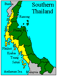 Hardest hit was the Southwest coast of Thailand, particularly Phuket and the resort areas of Phi Phi and Khao-Lak. It took about two hours for the first of the tsunami waves to reach the resort of Phi Phi island.
The arrival of the tsunami was heralded by a recession of the water which exposed the sea bottom for considerable distance, including previously submerged rocks. According to eyewitness reports, the first wave arrived at about 10:30 am local time and it was about 4 meters high. The second wave arrived about 2.5 minutes later and it was 7 meters. The third about 11 meters.The waves destroyed all beachfront hotels, bungalows and other structures at Phi Phi, hurling boats and other floating objects . All electricity and phone lines were cut. The hisghest reported wave was 11.6 meters at Khao-Lak beach.
Thai Government sources reported 5,313 deaths, 8,457 injuries and 4,499 missing, including more than 1,000 foreign tourists. Many of the missing are presumed dead. It is expected that these estimates will be revised upwards.
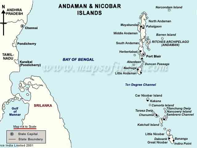
The estimated number of casualties in India is 16,000, but at least 6,000 more are missing. It is expected that the death toll will rise. Hardest hit were the Andaman and Nicobar Islands which were close to the tsunami generating area. Along India's southeastern coast, several villages were swept away, and thousands of fishermen at sea were missing. On the western coast of India' mainland, hardest hit was the state of Tamil Nadu.
Andaman and Nicobar Islands - The tsunami hit hard the Andaman and Nicobar group which comprises of a total of 572 islands of which 38 were significantly inhabited. Entire islands have been The waves literally washed away some of these islands, and there were reports that the island of Trinket had split in two. The Great Nicobar and Car Nicobar were the worst hit among all the southern Nicobar Islands because of their proximity to the earthquake's epicenter and relative low topography. The maximum tsunami wave reached a height of 15m. According to reports one fifth of the population of the Nicobar Islands is said to be dead, injured or missing. Chowra Island lost two thirds of its population of 1,500.
The official death toll is 812, but about 7,000 were reported as missing. The unofficial death toll (including those missing and presumed dead) is estimated to be about 7,000 and expected to rise. On 30 December 2004, four days after the great earthquake, Barren 1 volcano on Barren Island - located 135 kilometres (80 miles) northeast of the capital Port Blair - erupted.
Andhra Pradesh - There was significant loss of life and destruction. The affected districts were Krishna, Prakasam, Nellore, Guntur, West Godavari and East Godavari.
Kerala - The tsunami killed many people (official toll 168) and caused extensive destruction particularly at Kollam (131 dead), Alappuzha (32) and Ernakulam (5) were also affected.
Pondicherry - In the Union territory of Pondicherry, the affected districts were Pondicherry (107 dead), Karaikal (453 dead). The latest official toll was 560. An estimated 30,000 people were rendered homeless .
Tamil Nadu - The tsunami had a great impact on the state of Tamil Nadu on India's mainland with entire coastal villages destroyed. According to official reports the overall death toll in the state was 7,793. The Nagapattinam district had 5,525 casualties. The latest reported death toll at Velankanni was 1,500. Kanyakumari district has had 808 deaths, Cuddalore district 599, the state capital Chennai 206 and Kancheepuram district 124. The death tolls in other districts were Pudukkottai (15), Ramanathapuram (6), Tirunelveli (4), Thoothukudi (3), Tiruvallur (28), Thanjavur (22), Tiruvarur (10) and Viluppuram (47). The death toll may be significantly higher as many are still missing. The nuclear power plant at Kalpakkam was shut down after sea water rushed into a pump station. No radiation leak or damage to the reactor was reported.
The first of the tsunami waves took a little over two hours to reach Sri-Lanka. A clock on the western side of Sri Lanka at Colombo stopped at 9:20 in the morning, so the tsunami travel time to Colombo (first wave) must have been about 2 hours and 20 minutes. Sri-Lanka's south and east coasts were hardest hit. More than 50,000 people lost their lives - mostly children and the elderly. Most of them (more than 1,200) were in the eastern district of Batticaloa.
At Trincomalee in the northeast, the tsunami reached more than 2 km (1.25 mi) inland killing about 800 people. In the neighboring Amparai district alone, more than 5,000 people died. The naval base at Trincomalee was reported to be submerged. About 3,000 more people died in Mullaitivu and Vadamaradchi East. A train, known as the "Sea Queen", while traveling between Colombo and Galle, with 1,600 passengers on board, was struck and derailed by the tsunami. Only about 300 of the passengers survived. More than one and a half million people were displaced in Shri-Lanka and the death toll is expected to rise.
Despite Malaysia's proximity to the tsunami generating area, the impact of the waves was not as severe as in other countries in the region or countries thousands of kilometers away. Malaysia was partly sheltered by Sumatra and the tsunami waves attenuated somewhat in the Straits of Malacca. However, there were numerous deaths and destruction reported. The country's worst affected areas were the northern coastal areas and the outlying islands. Hardest hit were Penang,Kedah, Perak, Selangor and Langkawi. It was reported that the red flag warning system used by lifeguards on beaches in some resort areas in Penang helped reduce fatalities there. Houses in fishing villages along coastal areas were damaged in Batu Maung and Bayan Lepas in Penang. Coastal areas in Peninsular Malaysia e.g. 13 villages in Kuala Muda, Kedah and Kuala Triang in Langkawi island were also affected. About a quarter of the boats anchored in Rebak and Telaga harbour in Langkawi were damaged. The number of deaths currently stands at 68 with 52 in Penang, 10 in Kedah, 3 in Perak and 1 in Selangor. Another 6 are missing.
The mainland of Myanmar was somewhat sheltered from the full impact of the tsunami by the numerous offshore islands. Also the approximate North-South orientation of the tsunami generating area, resulted in waves of lesser amplitude traveling northward. Still the tsunami caused numerous deaths and destruction in Myanmar. Reportedly 90 people were killed, but eyewitnesses estimate that more than 600 people have died. 788 buildings have been reported as damaged or destroyed. 30,000 people were displaced.
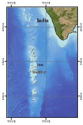 MALDIVES
The waves flooded two-thirds of Male, the capital. Hardest hit were the outlying low-level atolls. Some other low lying islands were completely submerged, including some where major resorts were located. Preliminary reports stated that the tsunami killed 82, that 26 are missing, and that there was extensive destruction. However, communications with remote islands were down and the death toll will probably rise. Thirteen islands have been abandoned because all buildings were destroyed and the fresh water supply was contaminated by the sea.
The tsunami waves traveled a distance of 4,500 km (2,800 miles) and struck Somalia on Africa's east coast. The height of the waves remains to be determined.
Hardest hit was the semi-autonomous Puntland area, particularly the region between Hafun in the Bari region and Garacad in the Mudug region. The narrow and low-lying peninsula of Hafun, 1150km (715 miles) northeast of Mogadishu, was particularly devastated.
The waves caused devastation in the Puntland area , striking the town mosque of Brava and destroying the villages of Beyla, Garacad, Muduy and Nugaal. Other coastal areas including Lower Juba were also affected. At Kulub and Hurdiye, all the fishing boats were either lost or destroyed.
According to a UN report 1,180 homes and 2,400 boats were destroyed. The main bridge which connects Hafun to the mainland was washed away. Te flooding rendered freshwater wells and reservoirs unusable.
A total of 298 people lost their lives and 50,000 more were displaced. The final death toll is expected to rise as there are many more missing.
No casualties were reported. The tsunami caused minor flooding along the northwestern coast and rurging activity was reported along Western Australia. At Geraldton, 425 km north of Perth, several boats were ripped from their moorings. At Busselton, 325 km south of Perth, a father and son in a boat were washed out to sea, but were subsequently rescued. Swimmers at Christmas Island were sucked 150m out to sea by the tsunami. Subsequently they were carried safely back to shore.
The tsunami's impact was relatively mild. The waves killed two children and capsized a tourist boat.
KENYA
There was minor damage. One person was reported drowned at Watamu, near Mombasa.
MADAGASCAR
The tsunami waves ranged from 1.6 meters to 10 meters along the souteastern coastal areas near the towns of Manakara, Sambava and Vohemar. There was considerable destruction - leaving about 1,000 people homeless - but no deaths were reported.
MAURITIUS
Waves completely submerged a village in the north of the island. There have been no reports of casualties.
OMAN
The tsunami hit the coastline but no casualties were reported.
REUNION ISLAND (France)
The tsunami sunk over 200 boats and caused considerable damage to port facilities.
SEYCHELLES
The tsunami killed three people. Seven more people are missing. The waves destroyed a major bridge in Port Victoria.
SOUTH AFRICA
A sea level rise of about 2-3 meters was reported for KwaZulu-Natal and Eastern Cape. One person was reported killed at Blue Horizon Bay near Port Elizabeth. A boy drowned in the Quinera River at Gonubie.
TANZANIA
The tsunami waves killed ten people. An unknown number of people are still missing. An oil tanker run run aground in Dar es Salaam harbor, damaging an oil pipeline.
More information on the tsunami effects in the Bay of Bengal and other areas of the Indian Ocean will be provided with a later update.
Tsunami waves varied in height. Maximum reported height was reported as being 10.5 meters, A detailed report on tsunami wave distribution for different of the stricken areas througout the Indian Ocean is being compiled from reports of eyewitnesses and other sources. A list of tsunami wave heigts as recorded by tide stations will be provided. However, most of the tide stations that recorded the tsunami are at distant locations. It is not known at this time whether any tide gauge stations closer to the tsunami generating area recorded the tsunami. An effort is being made to locate such records from tide stations that were not destroyed by the tsunami - if such stations exist,
Tsunami travel times for different areas in the Bay of Bengal and throughout the Indian Ocean are being compiled. Travel times of the first tsunami wave after the earthquake: Sumatra 10 minutes ,Thailand: 1 Hour, Sri Lanka: 2 hours, India: 2 Hours, East Africa: about 7 Hours.
Map of the Nicobar and Andaman Islands (Not to Scale)

Lessons Learned
 There were many lessons already learned from this tragic event in Southeast Asia. Many more lessons will be learned in the near future as this tragedy unfolds and reveals the many failures to value and protect human life in this neglected region of the world. Indeed a bitter lesson was already learned - that great earthquakes and destructive tsunamis do occur in this region.
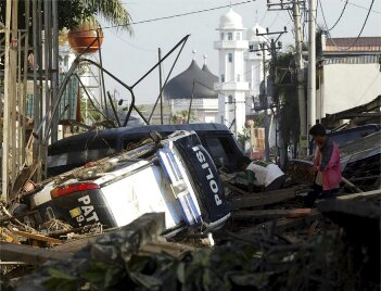
Tsunami Destruction at Banda Aceb, Northern Sumatra (photo of unknown origin )
The magnitude of the tsunami disaster could have been mitigated with a proper disaster preparedness plan and a functioning early warning system. A warning perhaps could not have been of much help in the immediate tsunami generating area of Sumatra and the Nicobar and Andaman islands, because the tsunami waves reached the shore very quickly. However the strong shaking by the earthquake should have been nature's warning for the local residents that a tsunami was imminent and they could have run to higher ground to save their lives. A simple program of public education and awareness of the potential hazard could have saved many lives in the immediate area.
The Tsunami Warning System which operates in the Pacific Region does not have the capability of extending a warning to countries bordering the Indian Ocean. Although the magnitude and location of the eartquake were quickly determined, there were no wave sensors in the area to confirm the generation of a tsunamni. Although both Indonesia and Thailand are members of the Pacific Tsunami Warning System network, they do not operate wave sensors on the western coast of their islands or territories.
India and Shri Lanka are not members of the international Warning System in the Pacifc and they have not shown interest in joining any regional early warning system. An erroneous belief has persisted that tsunamis do not occur frequently enough to warantee participation into a regional tsunami warning system. Local government authorities in the region did not even have a plan for disseminating warning information to the threatened coastlines - even if a warning had been provided. There was not even a basic educational plan for disaster preparedness. It should be obvious that such a program is necessary to prevent similar tragedies in the future.
No comments:
Post a Comment